- State:
- WASHINGTON-DC
- Site Type:
- Art Works, Murals
- New Deal Agencies:
- Arts Programs, Treasury Section of Fine Arts (TSFA)
- Completed:
- 1943
- Artist:
- Maxine Seelbinder
- Quality of Information:
- Good
- Site Survival:
- Extant
Description
“Although the ROD Building was a municipal building, the District of Columbia’s peculiar sovereignty status required that the federal government approve its construction, and that the Treasury Department Section of Fine Art play a major role in its art program…
The Treasury Sections December 1, 1942 announcement of the ROD Building mural competition was a term paper-like, ten page document that required artists to submit their entries unsigned for anonymous judging…
A press release announced that the winners wide geographic dispersion and almost equal female-male ratio, as well as the inclusion of accomplished African-American painter William Edouard Scott, proved the fairness of the blind selection process. Indeed, many of the artists selected had already painted murals for public buildings, and would have distinguished careers in the arts…”
(NRHP)
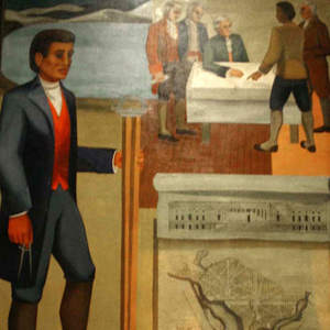
One muralist, Maxine Seelbinder, painted this oil on canvas mural “Benjamin Banneker.”
Source notes
Originally posted in the New Deal Art Registry: https://www.newdealartregistry.org/
National Register of Historic Places, 1990
At this Location:
- Recorder of Deeds Building (former) - Washington DC
- Recorder of Deeds Building: Scott Mural - Washington DC
- Recorder of Deeds Building: Mecklem Mural - Washington DC
- Recorder of Deeds Building: Portraits - Washington DC
- Recorder of Deeds Building: Levit Mural - Washington DC
- Recorder of Deeds Building: Lopez Mural - Washington DC
- Recorder of Deeds Building: Magafan Mural - Washington DC
- Recorder of Deeds Building: Schweig Mural - Washington DC
View all sites at Recorder of Deeds Building - Washington DC (9 Sites)
Site Details
Contribute to this Site
We welcome contributions of additional information on any New Deal site.
Submit More Information or Photographs for this New Deal Site

I am interested in the Seelbinder mural and hope to use it in a book I have written on early Chevy Chase history. (Three of the Ellicott/Banneker boundary stones are found in Chevy Chase.) Do you have information on the mural? I am guessing that the three figures at the table may be Washington (seated), Jefferson and possibly Pierre L’Enfant and the two at the right are Benjamin Banneker and Andrew Ellicott, the surveyors.
Do you have any notes from the artist on whom she intended to portray?.
Many thanks in advance for whatever information you can provide me.
Unfortunately, all we have is what is available on our site and through the sources listed.
From:
Sefton, D.P., DC Preservation League, Washington, DC (2010-07-01). “National Register of Historic Places Registration Form: Recorder of Deeds Building” (PDF). Washington, D.C: District of Columbia Office of Planning. Section 9, p. 19. (https://planning.dc.gov/sites/default/files/dc/sites/op/publication/attachments/Recorder%20of%20Deeds%20Building.pdf):
“The Treasury Section’s December 1, 1942 announcement of the ROD Building mural competition was a term paper-like, ten page document that required artists to submit their entries unsigned for anonymous judging. Mural subjects had been “carefully worked out by the Recorder…following intensive research.” Dr. Tompkins had determined that “in view of the history of the office of the Recorder of Deeds… the united theme… [will] reflect a phase of the contribution of the Negro to the American nation.” The announcement prescribed each of the seven mural’s placement, size, subject, and setting in detail, citing historical reference works for its content. For example, “Benjamin Banneker Surveys the District of Columbia” was to “show the presentation by Banneker and Mayor Ellicott, of the plans of the District of Columbia to the President, [and] Mr. Thomas Jefferson” in the presence of Benjamin Franklin and Alexander Hamilton.”
It therefore appears that Banneker and “Major” Andrew Ellicott are the men standing on the right side of the map. Thomas Jefferson is sitting at the table. George Washington (in a military uniform) and Alexander Hamilton are standing to the left of Jefferson. Benjamin Franklin is not in the picture, because his death occurred before the presentation could have occurred.
Additional information about the Seelbinder mural:
The website of the Library of Congress contains an enlargeable high-resolution image of the Seelbinder mural at https://cdn.loc.gov/master/pnp/highsm/09900/09905u.tif . By enlarging the image, viewers can see details of the painting, including those of the five men sitting at and standing near the table in the upper right corner of the mural.
Viewers can also see that Banneker is pointing to a map of the City of Washington as it existed before the City was planned and constructed. The map resembles the “View of the City of Washington in 1792” that is available on the Library’s website at https://cdn.loc.gov/master/gmd/gmd385/g3851/g3851g/ct001791.tif .
Viewers can also read an inscription on the large map in the forefront of the mural that states that the map is that of an 1800 (“MDCCC”) “Plan of the City of Washington”. Seelbinder appears to have used the 1792 engraving of the “Plan of the City of Washington in the Territory of Columbia” by Thackara & Vallance of Philadelphia that is available on the Library’s website at https://cdn.loc.gov/service/gmd/gmd385/g3850/g3850/ct004180.jp2 as the model for the mural’s copy of the Plan, but to have simplified and relocated the Plan’s legends.
Viewers can additionally read the inscription on the diagram of a building that is above the mural’s “Plan of the City of Washington” that states that the diagram is William Thornton’s design for the west view of the Capitol building. They can also see that the model of a building below the city plan is that of the White House.