- City:
- Davis, CA
- Site Type:
- Infrastructure and Utilities, Airports
- New Deal Agencies:
- Work Relief Programs, Works Progress Administration (WPA)
- Site Survival:
- No Longer Extant
Description
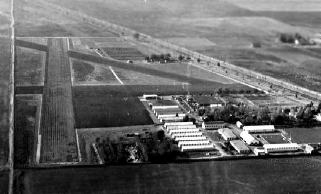
A 1940 WPA publication cites the WPA as having worked on the Davis State Forestry Airport sometime between 1935 and 1939. Although the exact date and extent of involvement is not known, the airport appears to have been built in the late 30s, so it is likely that the WPA was involved in the entire operation.
A separate source on airfields gives the following information about the airfield:
"The airfield at the State Nursery may not have yet been formally established by 1938, as it was not listed among active airfields in The Airport Directory Company's 1938 Airport Directory.
The earliest aeronautical chart depiction of the Davis airfield which has been located was on the 1939 Sacramento Sectional Chart (courtesy of Dann Shively). It depicted Davis as an auxiliary airfield.
At some point between 1939-41 the airfield was evidently renamed the State Forestry Airfield, as that is how it was listed in The Airport Directory Company's 1941 Airport Directory (courtesy of Chris Kennedy).
It was described as an auxiliary airfield, consisting of a triangular sandy loam field having 3 oiled runways, with the longest being the 2,608' east/west strip. A hangar was said to be marked with State Forestry Airport…
The last aeronautical chart depiction which has been located of the State Forestry Airport was on the September 1962 Sacramento Sectional Chart (courtesy of Chris Kennedy). It depicted the State Forestry Airport as having a 2,300' unpaved runway. Note that it also depicted the new El Macero Field in very close proximity.
The State Forestry Airfield was evidently abandoned (for reasons unknown) at some point between 1962-67, as it was no longer depicted on the 1967 Sacramento Sectional Chart or the 1970 USGS topo map."
– https://www.members.tripod.com/airfields_freeman/CA/Airfields_CA_SacramentoSW.htm#davis
Source notes
William R. Lawson. "Achievements, Federal Works Agency. Work Projects Administration, Northern California." 1940: 46.Contribute to this Site
We welcome contributions of additional information on any New Deal site.
Submit More Information or Photographs for this New Deal Site
I want to go here