Salt River Canyon Bridge – Gila County AZ

City:
Gila County

Site Type:
Infrastructure and Utilities, Roads, Bridges, and Tunnels

New Deal Agencies:
Public Works Funding, Public Works Administration (PWA)

Designer:
Lee Moor

Description

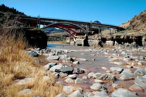
“The Salt River Canyon Bridge spans one of the most dramatic canyons in Arizona. It was funded by the Public Works Administration, designed in 1933 by architect Lee Moor, and completed in June 1934. The bridge is a single-span steel arch. The design of the bridge approach was highly complex because of the multiple curvatures. Its Art Deco superstructure shines in the sunlight and is still one of Arizona’s most visibly striking, engineered structures. Today the bridge carries only pedestrian traffic; a newer, wider version that sits adjacent handles automobile and truck traffic on Highway 60.”

Source notes

"The New Deal in Arizona: Connections to Our Historic Landscape," University of Arizona, The New Deal in Arizona Chapter of the National New Deal Preservation Association. https://www.library.arizona.edu/newdeal/map.html The above quote and additional photos can be found at: https://content.library.arizona.edu/cdm/singleitem/collection/NewDeal/id/207

Location Info


Salt River Canyon Bridge
AZ Gila  County

Coordinates: 33.7979, -110.5043

Contribute to this Site

We welcome contributions of additional information on any New Deal site.

Submit More Information or Photographs for this New Deal Site
4 comments on “Salt River Canyon Bridge – Gila County AZ

  1. I think Ralph Hoffman designed the Salt River Canyon Bridge

  2. J. Bradley

    I have spent my day trying to find out when the (pink) new, wider, automobile/truck traffic Salt River Canyon Bridge was built. I’ve been unsuccessful. Do you know and can you tell me?

  3. Jerry Phelps

    US 60 in Arizona follows the terrain closely as it winds its way down the Salt River Canyon. At the bottom lies this exquisite Art Moderne steel arch bridge from 1934. With its 162 foot span and decorative towers and railings, this bridge stands out among other steel arch bridges of the period. It was replaced by the Apache Bridge which opened in 1996. The Salt River Canyon bridge is now relegated to pedestrian traffic only.

  4. Twila Eakin

    I would appreciate any information on the Salt River “turnout” that was a stone and timber construction that existed in 1939 and 1940. It doesn’t exist today but I have a photo of my parents sitting at the structure. Did the CCC build it and when was it built? When was it torn down and why? Any information regarding this structure would be greatly appreciated.

Join the Conversation

Please note:

  • We are not involved in the management of New Deal sites and have no information about visits, hours or rentals.
  • This page shows all the information we have for this site; if you have new information or photos to share, click the button above.

Your email address will not be published, shared, or sold.

This site uses Akismet to reduce spam. Learn how your comment data is processed.

Contribute to this Site

We welcome contributions of additional information on any New Deal project site.

Submit More Information or Photographs for this New Deal Site

4 comments on “Salt River Canyon Bridge – Gila County AZ

  1. I think Ralph Hoffman designed the Salt River Canyon Bridge

  2. J. Bradley

    I have spent my day trying to find out when the (pink) new, wider, automobile/truck traffic Salt River Canyon Bridge was built. I’ve been unsuccessful. Do you know and can you tell me?

  3. Jerry Phelps

    US 60 in Arizona follows the terrain closely as it winds its way down the Salt River Canyon. At the bottom lies this exquisite Art Moderne steel arch bridge from 1934. With its 162 foot span and decorative towers and railings, this bridge stands out among other steel arch bridges of the period. It was replaced by the Apache Bridge which opened in 1996. The Salt River Canyon bridge is now relegated to pedestrian traffic only.

  4. Twila Eakin

    I would appreciate any information on the Salt River “turnout” that was a stone and timber construction that existed in 1939 and 1940. It doesn’t exist today but I have a photo of my parents sitting at the structure. Did the CCC build it and when was it built? When was it torn down and why? Any information regarding this structure would be greatly appreciated.

Join the Conversation

Please note:

  • We are not involved in the management of New Deal sites and have no information about visits, hours or rentals.
  • This page shows all the information we have for this site; if you have new information or photos to share, click the button above.

Your email address will not be published, shared, or sold.

This site uses Akismet to reduce spam. Learn how your comment data is processed.