Malheur National Wildlife Refuge and the New Deal

An anti-government occupier strolls by his New Deal-era shelter.


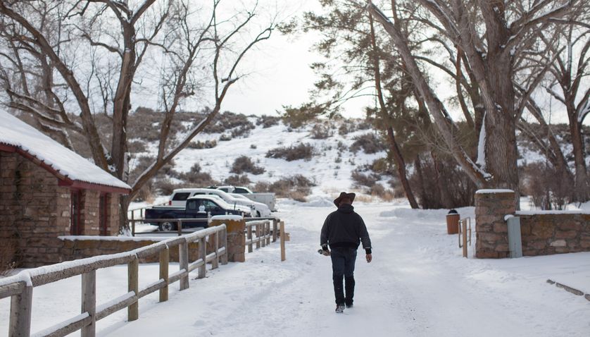
An anti-government occupier strolls by his New Deal-era shelter.  Source
Photo Credit: Rob Kerr/Getty Images NARRATIVE CONTENT GROUP, 2016

The Malheur National Wildlife Refuge has been much in the news lately.  It is the site of an armed standoff between a group of western ranchers and the US Fish and Wildlife Service. The conservative militants and their supporters are angry at the government’s perceived mistreatment of two local ranchers at the hands of the federal government (Mother Nature Network has a good run-down of the situation). Ironically, for a movement staking its claim on individual property rights and limited government, the occupiers owe their current shelter in snowy Oregon and, it seems, their “media center” to the greatest federal program ever undertaken in the United States: the New Deal.

As several Living New Deal team members noticed right away, Malheur National Wildlife Refuge is a New Deal site that has been up on our map for some time.  In 1908, President Theodore Roosevelt, backed by the Oregon Audubon Society, established the Malheur refuge on unclaimed government lands to serve “as a preserve and breeding ground for native birds” who were being killed in droves by plume hunters working for the hat industry.  A generation later, under the administration of Roosevelt’s fifth cousin, Franklin, the Civilian Conservation Corps (CCC) expanded the refuge, constructing dams, bridges, and roads, and erecting a number of handsome buildings that remain on the grounds.

The occupation of The Malheur National Wildlife Refuge has been approached from many angles: Aaron Bady’s analysis of the role of historical narration in the militia’s rhetoric and propaganda; debates about a “racial double standard” in the law’s treatment of the occupiers; and Charles Mudede’s meditations on class and the exploitation of labor, to name just a few.  But it’s worth noting another dimension of current events: The New Deal’s legacy is everywhere and its structures (as well as its lessons) are all-too-easily overlooked and forgotten.

Gabriel Milner is Project Manager for The Living New Deal. He is a trained cultural historian who teaches courses in U.S. History at the University of California, Berkeley, and Stanford University.

Paulina Lake Guard Station – Newberry National Volcanic Monument OR

Located within the Newberry National Volcanic Monument area of the Deschutes National Forest (approximately 36 miles southeast of Bend), the Paulina Lake Guard Station was built by Civilian Conservation Corps (CCC) employees in 1938 to house a seasonal ranger responsible for patrolling the campground and surrounding forest during wildfire season.  It currently houses the Paulina Visitors Center, the interpretive center for the Newberry Caldera.

Finished in horizontal clapboard, with vertical board and batten on its gable ends, the one-story wooden structure with an interior stone chimney reflects the rustic-style developed by the Forest Service in the Pacific Northwest during the early part of the twentieth century. As noted on its National Register nomination form, a recessed flagstone porch (surrounded on three sides) marks the entrance to the former residence. Given its architectural and historical significance, it received National Register of Historic Places status in 1986.

Camp Sisters Improvements – Camp Sherman OR

The Civilian Conservation Corps (CCC) Camp Sisters (F-110, Company #1454) at Camp Sherman, Oregon operated near the headwaters of the Metolius River in Jefferson County from 1933 to 1942. It was just one of the average 60 CCC camps that worked each year in the state during that period. Originally planned to be near Sisters, Oregon rather than at the unincorporated Camp Sherman site, its name tends to confuse Oregonians. The CCC, however, found this position on the Metolius more in keeping with project needs so located it where the (Camp Sherman) Riverside Campground is found today.

The CCC men constructed many of the facilities found along the upper Metolius River today, including tables, pine benches and picnic shelters (specifically the Camp Sherman, Pine Rest and Pioneer Ford shelters). They also built the trails along both sides of the river. In 1936, they also built the Suttle Lake-Camp Sherman road.

According to a plaque placed in 2004, the CCC workers “completed conservation projects, fought fires and removed beetle-killed trees. In the process they developed self-confidence, new skills and provided income for their families.”

Suttle Lake Campgrounds – Suttle Lake OR

Workers from the Camp Sisters Civilian Conservation Corps (Company #1454) provided the necessary labor for improvement to US Forest Service land on the south shore of Suttle Lake over a number of years (approx.. 1935-1937). The CCC workers constructed campgrounds, trails, picnic spots, and outdoor fireplaces.  In 1936, the CCC members built the Suttle Lake-Camp Sherman road.

On the south shore of Suttle Lake, a natural lake located within the Deschutes National Forest on the east side of the Cascades, are three large campgrounds and two day-use areas.

Cabin Lake Guard Station – Bend OR

Forty miles southeast of Bend, Oregon, the Cabin Lake Guard Station served as a district ranger station and headquarters for the Fort Rock Ranger District of the Deschutes National Forest from 1921 through 1945. Members of a Civilian Conservation Corps camp, located adjacent to the ranger station from 1934 to 1938, contributed to the area’s development for recreational use as well as improved its function for the Forest Service.

The CCC camp members built seven buildings for the ranger station, including the existing guard station building.  Six of these structures (ranger residences, a warehouse, maintenance shop, and a gas station) remain today. The seventh was moved to another guard station when the Cabin Lake Guard Station was closed. The rustic structures, wood-frame buildings with concrete foundation, are listed on the National Register of Historic Places. The Forest Service has discussed opening the former ranger residences for recreational rental use. The campground adjacent to the buildings is open.

Totem Square and Rock Retaining Wall – Sitka AK

A rock retaining wall was built by the Civilian Conservation Corps (CCC) in 1940 with the creation of Totem Square. The “Baranov” Totem Pole, also completed in 1941-42 as a project of the CCC under the supervision of the Forest Service. It was restored in 2010-2011 by local totem expert Tommy Joseph, using the original design drawing by George Benson, a local Tlingit. The Totem Pole has a controversial past surrounding both the construction of pole in Wrangell rather than Sitka as originally commissioned and for the original design, which many viewed as disrespectful and unrepresentative of the region’s history.

A record at the Simon Fraser University Digital Collections summarizes the history of the Totem: “The original intent for the Totem at Sitka Pioneer Home was to commemorate the peace treaty that Alexander Andreyevich Baranov helped broker in 1805 after the battle between the Russians and the Tlingit. The pole was commissioned by the U.S. Forest Service 135 years after a pivotal battle. The pole was made at the request of local Tlingit leaders of Sitka’s Kiksadi clan as a project of the Civilian Conservation Corps (CCC). The pole was carved in Wrangell much to the disappointment of the Sitka tribes since Wrangell and the Sitka tribes had a long history of conflict.”

Wrightsville Dam – Montpelier VT

A flood in 1927 brought about plans to construct four flood control projects, made possible by the New Deal and the Civilian Conservation Corps (CCC).

Wrightsville Dam is one of those. Construction began in August 1933  and was completed in October 1935. The dam is earthfill with stone slope protection. It is 1,525 feet long and 115 feet high.

The dam and reservoir are located on the North Branch of the Winooski River, about  three miles north of Montpelier on Route 12.  Its main purpose is to protect Montpelier.

According to the US Army Corps of Engineers: “Wrightsville Reservoir was one of four flood damage reduction projects constructed in Vermont by the Civilian Conservation Corps in the 1930s. Construction was overseen by the Corps’ North Atlantic Division. Because of accounting procedures, the construction costs of Wrightsville Reservoir were not calculated separately, but instead lumped together with the construction costs of East Barre Dam, Waterbury Reservoir, and the Winooski River Local Protection Project. The construction costs of these four projects totaled $13.7 million. Following completion, Wrightsville Reservoir was turned over to the State of Vermont for operation and maintenance.” (Army Corps)

In 1956-58, the dam was raised  20 feet and lengthened by 275 feet, and the spillway discharge channel was widened. (Army Corps)

Wrightsville Dam held in the great flood of July 2023 and received favorable newspaper coverage despite extensive flooding of Montpelier in that event  (Vermont Digger)

A key aspect of the Wrightsville Dam and the other flood control projects not mentioned in these sources is that they were built by a CCC company made up entirely of African American World War I veterans.

North Branch Cemetery – Middlesex VT

The Flood of 1927 brought many changes to Vermont, including the construction of several flood control dams built by the Civilian Conservation Corps (CCC). The CCC built one such dam at Wrightsville, in the northern part of Montpelier, Vermont and this project in turn required the relocation a cemetery in the effected area.

The Great Depression provided the labor needed to do the job and some CCC workers became involved with the labor to move the cemetery. Construction on the Wrightsville Dam began in July 1933, and the Vermont Public Service Commission ruled the “remains of the dead…shall be removed by the Board of the Public Works…and interred in some suitable cemetery.” Walter E. Cleveland (1895-1970) was chosen to supervise the transfer project. Active work began 4 October 1934 and the last of the 651 bodies was moved to the new site on 7 Nov 1934. The superintendent for the dam supplied CCC tools and labor but absolutely no project supervision for moving the cemetery, he insisted that be done by state workers from the State Board of Public Works. In his final report, Superintendent Walter E. Cleveland provided financial and materials data as well as information on what they found as the crew excavated the graves. He included several photos in the 1934 report.

Winooski River Local Protection Project – VT

The Winooski River Local Protection Project is located along a 6.5-mile stretch of the Winooski River which flows through Montpelier, Berlin, Moretown, and Middlesex. The Winooski River Local Protection Project protects several thousand acres of farmland and reduces flood damage in downstream communities, including Montpelier, Middlesex, Waterbury, and Duxbury.  

The project consisted of replacing an old timber dam at Montpelier by a small concrete dam (now called Bailey Dam); clearing and grading one mile of river bank above the dam, enlarging the channel, and adding rip-rap; and removing projecting ledges and points that restricted river flows at five spots between Middlesex and Montpelier. Construction began in 1934 and was completed in the spring of 1938.

It was planned and built in conjunction with East Barre Dam, Waterbury Dam, and Wrightsville Dam after the floods of 1927 and 1934.  “The Winooski River Local Protection Project was one of four flood damage reduction projects built in Vermont by the Civilian Conservation Corps in the 1930s. Construction was overseen by the Corps’ North Atlantic Division. Because of accounting procedures, the construction costs of this project were not calculated separately, but instead lumped together with the construction costs of East Barre Dam, Waterbury Reservoir, and Wrightsville Reservoir. The construction costs of these four projects totaled $13.7 million.” (Army Corps)


Waterbury Dam – Waterbury VT

The U.S. Army Corps of Engineers and the Civilian Conservation Corps (C.C.C.) combined efforts to construct the Waterbury Dam in Waterbury, Vermont during the Great Depression.

On November 3 and 4, 1927, torrential rains created a disastrous flood that paralyzed Vermont. Little River’s rising waters drove the valley residents to their roofs and isolated the hillside farmers. Fifty-five people in the Winooski Valley lost their lives, and property damage was estimated at $13,500,000. A second flood occurred in 1934.

These events spurred a plan by the US Army Corps of Engineers to built a set of four dams in central Vermont from 1933 to 1938.

Construction of the Waterbury Dam began in April 1935 and was completed in October 1938 by five thousand men of the U.S. Army Corps of Engineers and the CCC. (A power plant was added in 1956).

Waterbury Dam is earth fill with stone slope protection; it is 1,845 feet long and 187 feet high.

Nearby, at todays Little River Camp are the remains of the former CCC camp that operated from 1933 to 1939 and, when fully operating, had more than 80 buildings, and housed 2,000 men at its peak. CCC enrollees worked on the Waterbury and other dams, plus Mt. Mansfield State Park.

A key aspect of this and the other dams is that they were built by a CCC company made up entirely of African American World War I veterans.