- City:
- Montpelier, VT
- Site Type:
- Infrastructure and Utilities, Flood and Erosion Control, Dams
- New Deal Agencies:
- Work Relief Programs, Civilian Conservation Corps (CCC)
- Started:
- 1934
- Completed:
- 1938
- Quality of Information:
- Very Good
- Marked:
- Unknown
- Site Survival:
- Extant
Description
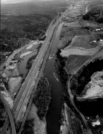
The Winooski River Local Protection Project is located along a 6.5-mile stretch of the Winooski River which flows through Montpelier, Berlin, Moretown, and Middlesex. The Winooski River Local Protection Project protects several thousand acres of farmland and reduces flood damage in downstream communities, including Montpelier, Middlesex, Waterbury, and Duxbury.
The project consisted of replacing an old timber dam at Montpelier by a small concrete dam (now called Bailey Dam); clearing and grading one mile of river bank above the dam, enlarging the channel, and adding rip-rap; and removing projecting ledges and points that restricted river flows at five spots between Middlesex and Montpelier. Construction began in 1934 and was completed in the spring of 1938.
It was planned and built in conjunction with East Barre Dam, Waterbury Dam, and Wrightsville Dam after the floods of 1927 and 1934. “The Winooski River Local Protection Project was one of four flood damage reduction projects built in Vermont by the Civilian Conservation Corps in the 1930s. Construction was overseen by the Corps’ North Atlantic Division. Because of accounting procedures, the construction costs of this project were not calculated separately, but instead lumped together with the construction costs of East Barre Dam, Waterbury Reservoir, and Wrightsville Reservoir. The construction costs of these four projects totaled $13.7 million.” (Army Corps)
Source notes
https://www.nae.usace.army.mil/Missions/CivilWorks/FloodRiskManagement/Vermont/Winooski.aspx
Site originally submitted by Andrew Laverdiere on December 16, 2014.
Contribute to this Site
We welcome contributions of additional information on any New Deal site.
Submit More Information or Photographs for this New Deal Site
Join the Conversation