- City:
- Institute, WV
- Site Type:
- Airports, Infrastructure and Utilities
- New Deal Agencies:
- Work Relief Programs, Works Progress Administration (WPA)
- Completed:
- 1936
- Quality of Information:
- Very Good
- Marked:
- No
- Site Survival:
- No Longer Extant
Description
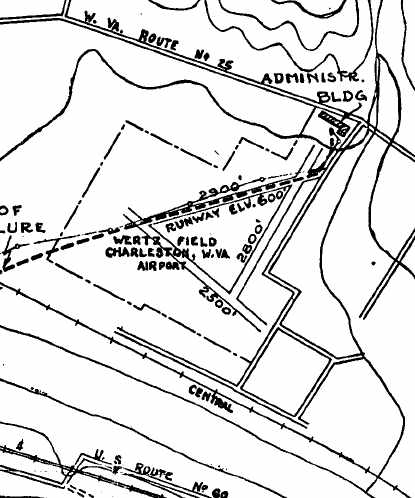
The Works Progress Administration extended and built additional facilities for the Wertz Airport in Charleston. The additions included an administration building. The airport serves today under the name Yeager Airport.
In 1930 Wertz field was developed in Institute. Operated by West Virginia Airways, Inc the field was named after Charleston Mayor W.W. Wertz. Commercial flight began with American Airlines in 1933 from the same field. The field was a popular site for air shows.
The WPA added improvements to the airport with “grading, ditch-digging and other work” by late 1936. Just after this West Virginia State College began the Civilian Pilot Training Program in 1937. In 1939, West Virginia State was one of the first black colleges to establish an aviation program authorized by the Civil Aeronautics Authority. Many graduates of the program would go on to serve with distinction as military pilots. Some of the men became part of the Tuskegee Airmen.
The airport closed and the land sold to the government for Wertz Field closed in May 1942. On the site Rubber Reserves Corporation to build and let to Carbide Chemicals what was noted in 1943 as “one of the largest [synthetic rubber plants] in the world.” The watch tower associated with Wertz Field and West Virginia Airways survives as part of West Virginia State University.
Interestingly, the WPA rejected funding the replacement airport, now known as Yeager Airport, which was promised with the loss of Wertz. Eventually, in In 1945, $2.75 million in federal aid was added to the $3 million in local bonds.
Source notes
National Archives Record Group 69-N
Charleston Daily Mail, 3 June 1937, p. 5
Ernest Blevins, “Aviation in Kanawha Valley Goes Back More Than 100 Years,” Charleston Gazette-Mail, 3 November 2017, p. 5A
48 WPA Projects Completed in West Va., Charleston Gazette April 26, 1936, p. 11.
“Wertz Field, Institute, WV” https://www.airfields-freeman.com/WV/Airfields_WV_SW.htm#wertz (accessed 16 November 2017)
Site originally submitted by Ernest Everett Blevins on November 16, 2017.
Additional contributions by Brent McKee, February 27, 2018.
Contribute to this Site
We welcome contributions of additional information on any New Deal site.
Submit More Information or Photographs for this New Deal Site


Join the Conversation