- City:
- Granville, MA
- Site Type:
- Parks and Recreation, Infrastructure and Utilities, Paths and Trails, Shelters, Picnic and Other Facilities, Bathhouses, Roads, Bridges, and Tunnels, Dams
- New Deal Agencies:
- Work Relief Programs, Civilian Conservation Corps (CCC)
- Started:
- 1933
- Completed:
- 1935
- Quality of Information:
- Very Good
- Site Survival:
- Extant
Description
Prior to colonial settlement, the area of Granville State Forest was inhabited by the Tunxis Native American tribe. In the mid-1700s, English pioneer Samuel Hubbard purchased the land for farming and pasturage, and the river that runs through the forest is now named the Hubbard River. The property was bought and owned by Tiffany and Pickett Lumber Company near the turn of the 20th century. In the 1920s, the Commonwealth obtained the land from the lumber company but little improvements were made before the CCC Camp was established.
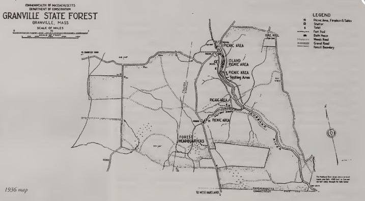
The Civilian Conservation Corps began work on Granville State Forest in 1933. CCC Camp SP-4 was located near the Halfway Brook area and housed Company 114. The CCC’s first order of business was to build roads and improve the area’s trees. They cut and cleaned areas for roads and trails and often built bridges and picnic tables with the trees. The CCC focused on two main areas in the Granville State Forest near Hubbard River and Halfway Brook. They built an earthen dam (that was later replaced with concrete) near Halfway Brook to control water flow. They also built bathhouses and lean-to, but they have since deteriorated. The current Halfway Brook Campground is located on the site of the former CCC Camp.
At the Hubbard Brook area, much of the work that the CCC completed in the 1930s is no longer in existence today. In this time, Company 114 built several rustic bridges, shelters, and latrines that are since gone, although the concrete foundations of the latrines remain. Most importantly the roads that the CCC built in Granville State Forest remain in use today. The forest had experienced severe flooding earlier in the 1930s and most of the primitive roads were destroyed. The roads the CCC made have proved more durable and long-lasting after years of use and maintenance.
Source notes
Berg, Shary Page. The Civilian Conservation Corps: Shaping the Forests and Parks of Massachusetts: A Statewide Survey of Civilian Conservation Corps Resources. Internet Archive. 1999. (Accessed August 30, 2016). "Granville State Forest." Office of Energy and Environmental Affairs. (Accessed August 30, 2016).Site originally submitted by Nikos Barry on December 6, 2016.
Contribute to this Site
We welcome contributions of additional information on any New Deal site.
Submit More Information or Photographs for this New Deal Site


Join the Conversation