- City:
- Burns, OR
- Site Type:
- Forestry and Agriculture
- New Deal Agencies:
- Civilian Conservation Corps (CCC), Conservation and Public Lands, Work Relief Programs, Grazing Service / Division of Grazing
- Started:
- 1934
- Completed:
- 1942
- Quality of Information:
- Good
- Marked:
- Yes
- Site Survival:
- Partially Extant
Description
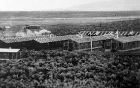
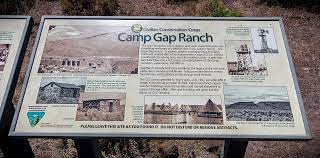
From 1934 to 1942, CCC Camp Gap Ranch operated in Harney County under the direction of the US Grazing Service, the precursor to the Bureau of Land Management (BLM). Enrollees at this 200-person Civilian Conservation Corps provided labor on projects designed to manage range land. As noted in a BLM brochure, this included building range improvements such as fences and reservoirs, drilling wells, building roads, and cutting large quantities of juniper posts for fencing projects.
CCC Camp Gap Ranch (DG-5) was one of seven Civilian Conservation Corps camps established in Oregon to work with the US Grazing Service in the implementation of the Taylor Grazing Act of 1934. The Taylor Act created grazing districts as a means to regulate use of public lands by Western ranchers with the goal of improving livestock management and the management of watersheds.
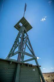
Several of CCC Camp Gap Ranch’s original structures remain on-site, including a stone cold storage building, the stone South House, a windmill that provided water for the camp, and a rock fence. The Burns District BLM office works to preserve the camp structures and encourages hikers to “use, share, (and) appreciate” the area as part of our federal public lands.
Source notes
"Camp Gap Ranch," Public Lands USA: Use, Share, Appreciate brochure. Bureau of Land Management - Burns District. https://www.blm.gov/or/resources/recreation/files/brochures/CampGapRanch.pdf
Site originally submitted by Jim Reed on January 28, 2023.
Additional contributions by Judith T Kenny.
Contribute to this Site
We welcome contributions of additional information on any New Deal site.
Submit More Information or Photographs for this New Deal Site


Join the Conversation