
Date added: June 19, 2017; Modified: June 20, 2017
The Patten Colony Farm is a historic structure representative of the farmsteads associated with the Alaska Rural Rehabilitation Corporation’s Matanuska Colony project, established with help of the Federal Emergency Relief Administration. The complex includes a log house, two log and… read more
Date added: June 15, 2017; Modified: June 15, 2017
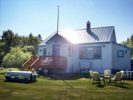
The Berry House is a farm house built in 1935 as part of the Alaska Rural Rehabilitation Corporation’s Matanuska Colony project. Representative of the frame colony farm house typology, the Berry house retains most of its original features and it… read more
Date added: June 14, 2017
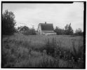
“The Bailey Colony Farm is a farmstead associated with the 1930s Alaska Rural Rehabilitation Project in the Matanuska Valley. Although the original forty-acre tract has been subdivided, the house and barn that were built in 1935 remain and, virtually unaltered,… read more

Date added: March 16, 2016; Modified: June 14, 2017
The Sitka Pioneers’ Home was built with financial assistance from the PWA, ca. 1935, and served as “a home for aged pioneers” (source note 1). It was listed on the National Register of Historic Places in 1979 (source note 2)… read more

Date added: June 14, 2017; Modified: June 14, 2017
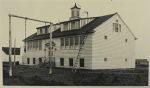
The addition to the Main School was built with the help of the Public Works Administration. The main structure was built in 1934, and it replaced a wooden structure that had previously served as the city’s only school. “By the… read more
Date added: May 26, 2017; Modified: June 14, 2017
The CCC undertook “construction of a mile-long spur road off the Palmer Highway between Eagle River and Eklutna.”

Date added: June 13, 2017; Modified: June 14, 2017
The city of Fairbanks built the City Hall with the help of a grant from the Public Works Administration. After a fire that destroyed several public buildings, the city requested PWA funds to replace an inadequate wood structure that housed the… read more
Date added: June 13, 2017; Modified: June 13, 2017
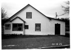
The Herried House, also known as Grow House, was built by the Work Progress Administration. the house was originally part of a colony farm. The structure “is an example of a farm house associated with the Alaska Rural Rehabilitation Corporation project… read more
Date added: June 12, 2017; Modified: June 13, 2017
The Public Works Administration (PWA) contributed approximately $5,400 toward the construction of the Aleknagik Schoolhouse Inn in 1938. Built as a territorial school in 1933, the facility initially consisted of a log cabin. In 1938, the PWA built a two-story structure. The… read more
Date added: June 13, 2017; Modified: June 13, 2017
The Unalakleet School was built in 1933 by the Bureau of Indian Affairs with the help of a PWA grant. “The BIA constructed the building in 1933 for a day school in the community. A staff architect most likely designed the building. A… read more

Date added: June 12, 2017; Modified: June 13, 2017
The Mayflower School was built and the cost of $9,500 by the Bureau of Indian Affairs, with the help of a PWA grant. Lester Troster, a local architect and superintendent of the regional Bureau of Indian Affairs, designed the two story structure.1… read more
Date added: June 12, 2017; Modified: June 12, 2017
The Works Progress Administration contributed $42,732 toward sewer and street improvement work in Ketchikan, Alaska, between 1939 and 1940.
Date added: June 12, 2017
The Works Progress Administration contributed $12,714 toward improvements to a storage dam and several streets in Wrangell, Alaska, between 1939 and 1940.
Date added: June 12, 2017; Modified: June 12, 2017
The Works Progress Administration contributed $8,135 toward sewers construction in Petersburg, Alaska, between 1939 and 1940.
Date added: June 12, 2017
The Works Progress Administration contributed $1,909 toward streets and school grounds improvements in Skagway, Alaska, between 1939 and 1940.